Druid Stones at St. Catherine's
Query #16 - "Druid Stones" at St. Catherine's
'08/07/1933
Can anyone give any information about some stones at Beeks, near St. Catherine's, which are marked on the Ordnance map as Druidical Stones? They are always spoken of in the neighbourhood as "The Druid's Stones."
They are in Hill's Wood, on sloping ground near Beeks' Farm, and consist of three large stones in a straight line up the bank, and from the centre of the lowest one a thorn tree, with a trunk divided into three, is growing. The thorn tree must be of some age, as one trunk is covered with thick twisted branches of ivy. What look like the remains of a stone circle can be traced nearby.
The stones are just in Gloucestershire, the small brook at the bottom of the valley being part of the boundary between the counties of Gloucester and Somerset.
I was also told of some caves in the same neighbourhood which have now become overgrown or filled up. F. C. T., Bath.
Replies
22/07/1933
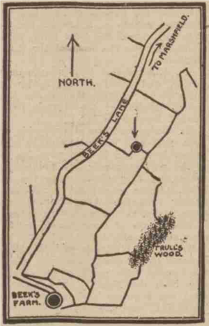
For comments on these stones see "Long Barrows of the Cotswolds," by O. G. S. Crawford, 1925, p. 223. The experienced author, who is the Archaeology Officer of the Ordnance Survey, does not accept any of the stones in Trull's Wood as of archaeological interest. Trull's Wood (O.S.) is the only wood near Beek's Farm and presumably is the Hill's Wood of F.C.T.'s query. The author remarks that the site as marked on the small scale map of 1830 on the higher ground above Beek's Farm and not on the slopes. About 10 years ago the writer was asked to search the higher ground, the assumption being that when the original survey was made there were stones there. On following Beek's Lane from Marshfield, three fields before the farm, a slight rise was noticed under the hedge on the south side of the field, there being an angle the hedge at that point. On the spot there were a number of stone fragments. The writer conjectured that this was the site of the stones, and that they had been broken up on the spot. Digging might prove or disprove the conjecture. If the sockets of the stones could be found it would be confirmation. I enclose a tracing of the site taken from the 6in. O.S. map for F.C.T. Perhaps inquiries by F.C.T. locally might furnish information. For purposes of record I give the site as Lat. 51deg., 26min. 50 ½ sec.; Long. 2deg., 20min. 3sec—A.T.W., Monkton Combe.
